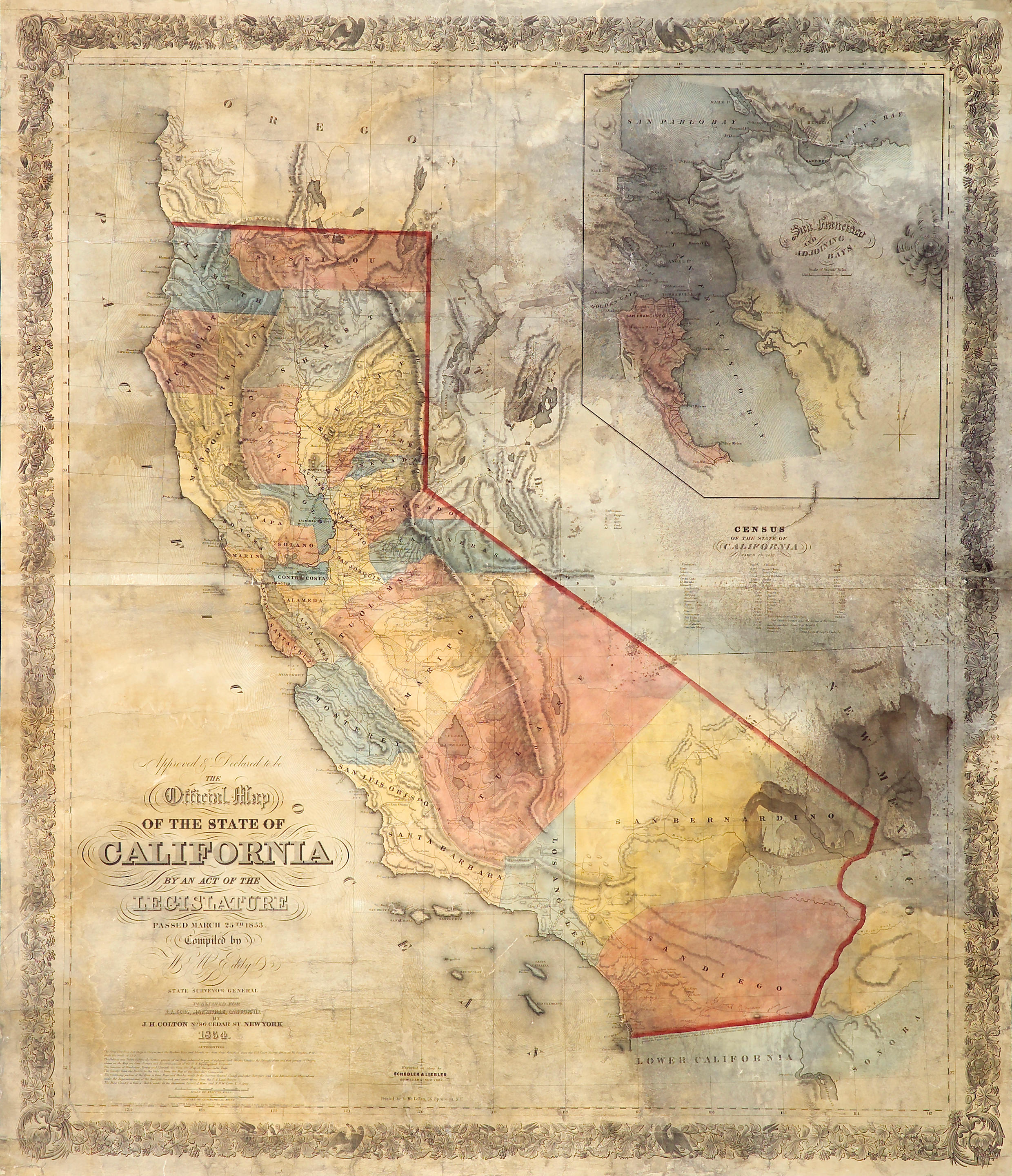
Title: Approved & Declared to be The Official Map of the State of California by an Act of the Legislature Passed March 25th 1853. Compiled by W.M. Eddy, State Surveyor General. Published for R.A. Eddy, Marysville, California... Author: Eddy William M. Place: New York Publisher: J.H. Colton Date: 1854 Description: Lithographed map, hand-colored. 126.4x97.8 cm. (49x38½") plus ornamental border, folding into original blindstamped red leather folder lettered in gilt, 15.5x10.5 cm. (6¼x4"), Colton advertisement on inside of front cover. Exceptional example of this seminal and important map of California, in original state, not laid down or backed as a large proportion of the few remaining are, the coloring bright, the paper crisp and clean. This was the first official map of the state of California, fixing the borders that are, for the most part, known today. The basic boundaries were laid down at the State Constitutional Convention of 1849, and one of the first acts of the State Surveyor General was to call for the State Surveyor General to prepare a map of the state. In early 1852, William Eddy, the second Surveyor General, after some wrangling with the legislature over his budget, conducted a survey of the central part of the state, with his reduced budget necessitating that the remaining topographical information be supplied by the United States Coast Survey and other sources. The map was completed and accepted in manuscript form in March of 1853. Warren Heckrotte notes that “Eddy’s map is large, in full color, and is splendid in appearance.” It advanced the mapping of California in significant ways beyond the setting of its boundaries. It was the first map to show the eastern slope of the Sierra Nevada in its approximately correct location. Additionally, it contains a large and generally accurate inset map of San Francisco Bay. Heckrotte states that "Eddy's map was a good map, the best up to this time, but nevertheless it had flaws. Because it was the 'Official Map' it was judged harshly, one critic calling it 'shameful'... The most glaring error is the position of the diagonal portion of the boundary which runs too far to the east... an error which arose from a map of the Topographical Engineers that Eddy used... The State Legislature accepted the finished map, but with the caveat that it would not be bound by the representation of the eastern border..." Despite these flaws, the map remained as accurate as any for some twenty years, when in 1873 the California Geological Survey produced a map based on a trigonometric survey of the whole state, which required a full decade of work. Extremely rare, especially in the original state. The last copy to sell at auction was in 2005, which was laid down on new linen; prior to that, the most recent auction record is for a copy sold in 1982. The Streeter copy, sold in 1968, was silked. The present copy is not mounted or silked, in the original covers without any repairs. It has an early ownership signature on the inside of the front cover, "Geo. F. Crane, Poker Flat, Sep. 30th, '54." Poker Flat was a mining town in Sierra County, California, north of Downieville. Cohen, Mapping the West, pp.167-69; Heckrotte, California 49, Map 34; Streeter Sale 2761; Wheat, Maps of the California Gold Region, 257. Lot Amendments Condition: Just a touch of rubbing to extremities of folder; map splitting along the horizontal crease parallel to the bottom of the folder, with no loss, slight darkening along that crease and to two other adjacent folds, just a few faint fox marks; a bright, clean and crisp copy. Item number: 213986
Title: Approved & Declared to be The Official Map of the State of California by an Act of the Legislature Passed March 25th 1853. Compiled by W.M. Eddy, State Surveyor General. Published for R.A. Eddy, Marysville, California... Author: Eddy William M. Place: New York Publisher: J.H. Colton Date: 1854 Description: Lithographed map, hand-colored. 126.4x97.8 cm. (49x38½") plus ornamental border, folding into original blindstamped red leather folder lettered in gilt, 15.5x10.5 cm. (6¼x4"), Colton advertisement on inside of front cover. Exceptional example of this seminal and important map of California, in original state, not laid down or backed as a large proportion of the few remaining are, the coloring bright, the paper crisp and clean. This was the first official map of the state of California, fixing the borders that are, for the most part, known today. The basic boundaries were laid down at the State Constitutional Convention of 1849, and one of the first acts of the State Surveyor General was to call for the State Surveyor General to prepare a map of the state. In early 1852, William Eddy, the second Surveyor General, after some wrangling with the legislature over his budget, conducted a survey of the central part of the state, with his reduced budget necessitating that the remaining topographical information be supplied by the United States Coast Survey and other sources. The map was completed and accepted in manuscript form in March of 1853. Warren Heckrotte notes that “Eddy’s map is large, in full color, and is splendid in appearance.” It advanced the mapping of California in significant ways beyond the setting of its boundaries. It was the first map to show the eastern slope of the Sierra Nevada in its approximately correct location. Additionally, it contains a large and generally accurate inset map of San Francisco Bay. Heckrotte states that "Eddy's map was a good map, the best up to this time, but nevertheless it had flaws. Because it was the 'Official Map' it was judged harshly, one critic calling it 'shameful'... The most glaring error is the position of the diagonal portion of the boundary which runs too far to the east... an error which arose from a map of the Topographical Engineers that Eddy used... The State Legislature accepted the finished map, but with the caveat that it would not be bound by the representation of the eastern border..." Despite these flaws, the map remained as accurate as any for some twenty years, when in 1873 the California Geological Survey produced a map based on a trigonometric survey of the whole state, which required a full decade of work. Extremely rare, especially in the original state. The last copy to sell at auction was in 2005, which was laid down on new linen; prior to that, the most recent auction record is for a copy sold in 1982. The Streeter copy, sold in 1968, was silked. The present copy is not mounted or silked, in the original covers without any repairs. It has an early ownership signature on the inside of the front cover, "Geo. F. Crane, Poker Flat, Sep. 30th, '54." Poker Flat was a mining town in Sierra County, California, north of Downieville. Cohen, Mapping the West, pp.167-69; Heckrotte, California 49, Map 34; Streeter Sale 2761; Wheat, Maps of the California Gold Region, 257. Lot Amendments Condition: Just a touch of rubbing to extremities of folder; map splitting along the horizontal crease parallel to the bottom of the folder, with no loss, slight darkening along that crease and to two other adjacent folds, just a few faint fox marks; a bright, clean and crisp copy. Item number: 213986










Testen Sie LotSearch und seine Premium-Features 7 Tage - ohne Kosten!
Lassen Sie sich automatisch über neue Objekte in kommenden Auktionen benachrichtigen.
Suchauftrag anlegen