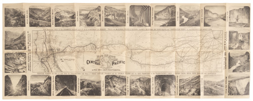
Title: Map of the Central Pacific Railroad and its Connections Author: Central Pacific Railroad Place: No place Publisher: Date: 1872 Description: Wood-engraved map. Map measures 15x65 cm (6x27½") on sheet 21x96 cm (8¼x37¾"), with 24 wood-engraved views/scenes on recto (2 on each side of the map & 20 on the verso). Scarce route map of the Central Pacific Railroad eastward to Omaha with the Kansas Pacific splitting off at Cheyenne to Denver and thence to Kansas City, with numerous connections to Chicago and elsewhere from those terminals. The engravings show scenes along the way, almost all in California. The views are taken from photographs by Alfred A. Hart (noted by Mead Kibbey in his book on Hart, p.78). Text in the top margin reads: "New Route for '1872' to the Yosemite Valley via C.P.R.R. to Lathrop and Merced. Thence via Mariposa, White & Hatch's, Clark's, Mariposa Big Tree Grove and 'Inspiration Point,' or, via Coulterville Short Line." And in the bottom margin: "Through Tickets for Sale to and from the Principal Ports and Cities of Great Britain, France and the German States, and via San Francisco to the Trans-Pacific Ports of Japan, China, India, New Zealand and Australia." Provenance: Harrison, 3/93 References: Currey & Kruska, no.68 (not seen). Eberstadt cat 158, California Delineated, no. 47 (C&K's source). Kibbey,The Railroad Photographs of Alfred A. Hart, Artist, reproduces a copy of this that has the views, 24 in number, surrounding the map and timetables on verso (p.78). Lot Amendments Condition: Very good, with old folds. Item number: 265165
Title: Map of the Central Pacific Railroad and its Connections Author: Central Pacific Railroad Place: No place Publisher: Date: 1872 Description: Wood-engraved map. Map measures 15x65 cm (6x27½") on sheet 21x96 cm (8¼x37¾"), with 24 wood-engraved views/scenes on recto (2 on each side of the map & 20 on the verso). Scarce route map of the Central Pacific Railroad eastward to Omaha with the Kansas Pacific splitting off at Cheyenne to Denver and thence to Kansas City, with numerous connections to Chicago and elsewhere from those terminals. The engravings show scenes along the way, almost all in California. The views are taken from photographs by Alfred A. Hart (noted by Mead Kibbey in his book on Hart, p.78). Text in the top margin reads: "New Route for '1872' to the Yosemite Valley via C.P.R.R. to Lathrop and Merced. Thence via Mariposa, White & Hatch's, Clark's, Mariposa Big Tree Grove and 'Inspiration Point,' or, via Coulterville Short Line." And in the bottom margin: "Through Tickets for Sale to and from the Principal Ports and Cities of Great Britain, France and the German States, and via San Francisco to the Trans-Pacific Ports of Japan, China, India, New Zealand and Australia." Provenance: Harrison, 3/93 References: Currey & Kruska, no.68 (not seen). Eberstadt cat 158, California Delineated, no. 47 (C&K's source). Kibbey,The Railroad Photographs of Alfred A. Hart, Artist, reproduces a copy of this that has the views, 24 in number, surrounding the map and timetables on verso (p.78). Lot Amendments Condition: Very good, with old folds. Item number: 265165


Testen Sie LotSearch und seine Premium-Features 7 Tage - ohne Kosten!
Lassen Sie sich automatisch über neue Objekte in kommenden Auktionen benachrichtigen.
Suchauftrag anlegen