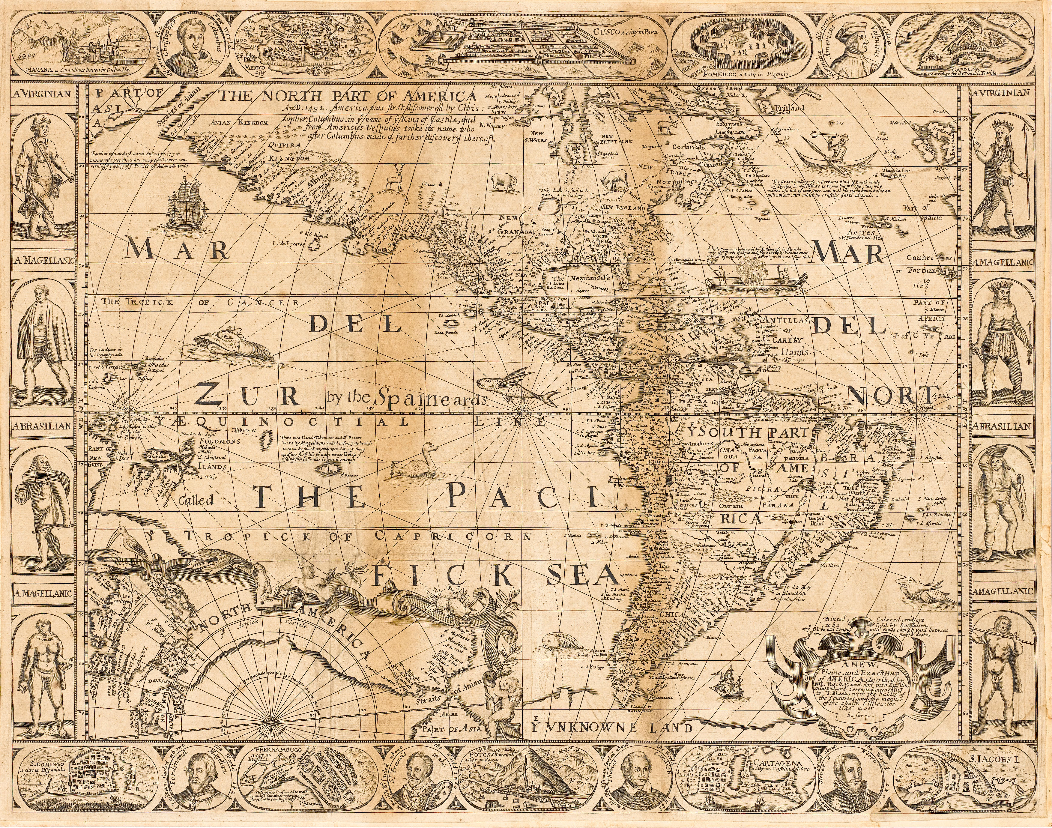
WALTON, ROBERT. A New, Plaine, and Exact Map of America: described by N.I. Visscher, and don into English, enlarged, and Corrected, according to I. Blaeu. London: Robert Walton [c. 1660]. Engraved map, single sheet, 439 x 540 mm. (17¼ x 21 3/8 in.), mounting tape at upper margin, creased three times vertically and once laterally from old folding and with small repaired tear to centerfold, two 1/2-inch tears at upper margin just entering image, a few small tears to upper margin, washed and pressed . State 2, undated, inset map of the Arctic Circle showing the Northwest Passage, upper and lower borders incorporating medallion portraits of the Columbus, Vespucci, Magellan, Drake, Cavendish and van Noort, and inset oval views of American forts and cities, side borders with vignettes of native Americans, embellished with sea monsters, flying fish, ships and canoes. Burden 330; Tooley, "California as an Island," no. 25, and "A Sequence of Maps of America," p. 304, both in The Mapping of America , pp. 119 and 304. THIS VERY RARE MAP IS THE ONLY KNOWN MAP TO SHOW CALIFORNIA IN AN INTERMEDIATE STATE BETWEEN AN ISLAND AND A PENINSULA. The map derives from Pieter van den Keere's 1614 map of the Americas and from its 6th state of 1652 in particular, closely copying the figurative borders and correctly showing Statenlant as an island off the tip of South America. Its curious representation of California is however unique. "This is an extremely interesting and uncommon map being an intermediate state in the geographical conception of the West Coast, the only map I know to show this compromise solution in the controversy as to whether California was an island or a peninsula. California is shown as an island on the revised Sanson model but the coast is continued north-westwards in the old Mercator-Ortelius tradition. New Albion is shown on the mainland coast far to the north of the island, and the island itself is named California" (Tooley). "The fascinating depiction of California attempts to balance the many theories at the time... A further improvement is the inclusion of Hudson Bay... The east coast of North America is improved in an elementary manner, including Boston, but not Jamestown... This rare map is not known to have been intended for any book although it has been found inserted into examples of Heylin's Cosmographie and Varenius' Cosmography and Geography " (Burden).
WALTON, ROBERT. A New, Plaine, and Exact Map of America: described by N.I. Visscher, and don into English, enlarged, and Corrected, according to I. Blaeu. London: Robert Walton [c. 1660]. Engraved map, single sheet, 439 x 540 mm. (17¼ x 21 3/8 in.), mounting tape at upper margin, creased three times vertically and once laterally from old folding and with small repaired tear to centerfold, two 1/2-inch tears at upper margin just entering image, a few small tears to upper margin, washed and pressed . State 2, undated, inset map of the Arctic Circle showing the Northwest Passage, upper and lower borders incorporating medallion portraits of the Columbus, Vespucci, Magellan, Drake, Cavendish and van Noort, and inset oval views of American forts and cities, side borders with vignettes of native Americans, embellished with sea monsters, flying fish, ships and canoes. Burden 330; Tooley, "California as an Island," no. 25, and "A Sequence of Maps of America," p. 304, both in The Mapping of America , pp. 119 and 304. THIS VERY RARE MAP IS THE ONLY KNOWN MAP TO SHOW CALIFORNIA IN AN INTERMEDIATE STATE BETWEEN AN ISLAND AND A PENINSULA. The map derives from Pieter van den Keere's 1614 map of the Americas and from its 6th state of 1652 in particular, closely copying the figurative borders and correctly showing Statenlant as an island off the tip of South America. Its curious representation of California is however unique. "This is an extremely interesting and uncommon map being an intermediate state in the geographical conception of the West Coast, the only map I know to show this compromise solution in the controversy as to whether California was an island or a peninsula. California is shown as an island on the revised Sanson model but the coast is continued north-westwards in the old Mercator-Ortelius tradition. New Albion is shown on the mainland coast far to the north of the island, and the island itself is named California" (Tooley). "The fascinating depiction of California attempts to balance the many theories at the time... A further improvement is the inclusion of Hudson Bay... The east coast of North America is improved in an elementary manner, including Boston, but not Jamestown... This rare map is not known to have been intended for any book although it has been found inserted into examples of Heylin's Cosmographie and Varenius' Cosmography and Geography " (Burden).


.jpg?height=400)
Testen Sie LotSearch und seine Premium-Features 7 Tage - ohne Kosten!
Lassen Sie sich automatisch über neue Objekte in kommenden Auktionen benachrichtigen.
Suchauftrag anlegen