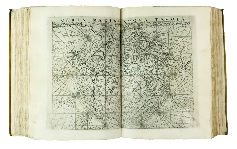
La Geografia… Nuovamente tradotta di Greco in Italiano, da Girolamo Ruscelli Con Espositioni del medesimo…[With:] Ruscelli, Espositioni et introduttioni universali. [And with:] Giuseppe MOLETO, Discorso universale.
Venice: Vincenzo Valgrisi, 1561. Three parts in one volume. 4to (220 x 150 mm). Woodcut printer’s device to all three titles and to verso of final leaf of the second, six-line historiated woodcut initials, some with initial spaces with guide-letter but no woodcut. Numerous diagrams and 64 double-page engraved maps, comprising 28 known to the ancients ( Geografia ) and 36 “new” engravings ( Espositioni ), all numbered individually. French olive morocco with the arms of Charles D'Orléans-Valois, Duc d'Angoulême [son of Charles IX] (d.1650), tooled in gilt with intertwining C’s to corners and five of six spine compartments, gilt edges. Contained in a cloth drop-back box. Condition: thumbsoiling, some maps strengthened at gutter, lower outer corner of preliminary quire and the final part, Discorso universale, frayed gradually at lower outer corner; the binding carefully rebacked preserving the original backstrip, joints slightly cracking, extremities lightly rubbed with loss to gilt at corners. Provenance: “ex bibliotheca minimorum auichiensium” (early inscription in ink to title); Charles D'Orleans-Valois (binding); “Ex Libris Guillard Natu Minoris” [likely Jérôme Guillard, 1763-1808] (bookplate to front pastedown); “Ex Libris José M. Rodriguez MCMXXXVIII/ Bibliotheca Chizigonana” (inscription on front pastedown); Harrison D. Horblit (bookplate); later bookseller’s mark in ink to upper corner of front pastedown. Acquisition : purchased from H. P. Kraus (1998), $8,360. the charles d'orleans-valois-horblit copy of a seminal italian edition of ptolemy’s geography , a very fine copy with jacopo gastaldi’s maps enlarged from the first italian edition of pietro andrea mattioli (1548) . The maps include the first widely circulated edition of Nicolo Zeno’s map of the North Atlantic (Venice, 1558), showing Greenland connected with Norway and two land masses to the far west called Estotiland and Drogheo. Among the double-page maps are ten relating to America. The Nueva Hispania (no.31, Espositioni ) shows the Yucatan as a peninsula rather than an island as in the 1548 edition. The world map Orbis descriptio (sig.†) is drawn on a new projection; Ruscelli explains in his description of it that Ptolemy could not have adequately described the spherical projection as such, having knowledge of just one quarter of it when he composed his Geography in the second century AD. With an important mathematical treatise by Moleto, followed by indices to the maps. From the library of Charles D'Orléans-Valois, this copy belonging to him and his mistress, Marie Touchet. Sabin 66503; European Americana 561/42; Adams P-2235; JCB I, 214. Shirley Mapping of the World 110,111.


Testen Sie LotSearch und seine Premium-Features 7 Tage - ohne Kosten!
Lassen Sie sich automatisch über neue Objekte in kommenden Auktionen benachrichtigen.
Suchauftrag anlegen