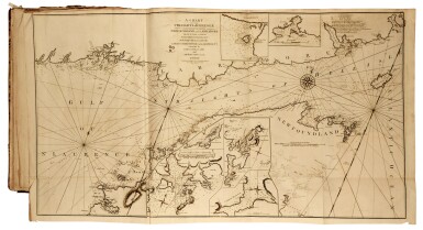
NORTH AMERICAN PILOT. The North American Pilot for Newfoundland, Labradore, the Gulf and River St. Laurence: being a collection of sixty accurate Charts and Plans, drawn from original surveys: taken by James Cook and Michael Lane, Surveyors, and Joseph Gilbert, and other Officers...chiefly engraved by The late Thomas Jefferys...on thirty-six large copper-plates. London: Printed...and sold by R. Sayer and J. Bennett 1784 (--Part the Second.) The North-American Pilot for New England, New York, Pennsylvania, Maryland, and Virginia; also the Two Carolinas, and Florida...taken by Capt. John Gascoigne, Joshua Fisher, Jacob Blamey, and other Officers. London: Printed and sold by R. Sayer and J. Bennett 1783). 2 vols., atlas folio, 547 x 390mm. (21 1/2 x 15 1/8in.), on guards, contemporary russia gilt with broad gilt swirling flower tool and Greek key borders (a remboîtage), some repairs to folds and occasional fold tears, some repairs, mostly at edges and to some folds, also to title of vol. 2 (which has some letters strengthened in the third line), occasional minor soiling . Letterpress title in each vol., dedication leaf to Sir Hugh Palliser and one leaf (2pp.) index of charts in vol. 1, 35 engraved charts (numbered 1-22; 1-13), 6 of them single-page, 16 double-page and 12 folding, chart 6 of vol. 1 with overslip; many map-sheets with more than one chart, some charts published 1786. James Cook conveyed his rights to the Newfoundland charts to Thomas Jefferys in 1768 before his first voyage around the world in Endeavour . Jefferys used them and others to form the " Collection of Charts of 1769-70, a prototype or assay for the celebrated North-American Pilot which was to be published in five English editions from 1775 to 1806 and copied in a French version of 1784"--R.A. Skelton and R.V. Tooley, "The Marine surveys of James Cook in North America 1758-1768 particularly the Survey of Newfoundland" (R.V. Tooley, The Mapping of America , 1980, p. 180); Sabin 55557; this edition not in Phillips (cf 1209 for the 1777 edition); (2)
NORTH AMERICAN PILOT. The North American Pilot for Newfoundland, Labradore, the Gulf and River St. Laurence: being a collection of sixty accurate Charts and Plans, drawn from original surveys: taken by James Cook and Michael Lane, Surveyors, and Joseph Gilbert, and other Officers...chiefly engraved by The late Thomas Jefferys...on thirty-six large copper-plates. London: Printed...and sold by R. Sayer and J. Bennett 1784 (--Part the Second.) The North-American Pilot for New England, New York, Pennsylvania, Maryland, and Virginia; also the Two Carolinas, and Florida...taken by Capt. John Gascoigne, Joshua Fisher, Jacob Blamey, and other Officers. London: Printed and sold by R. Sayer and J. Bennett 1783). 2 vols., atlas folio, 547 x 390mm. (21 1/2 x 15 1/8in.), on guards, contemporary russia gilt with broad gilt swirling flower tool and Greek key borders (a remboîtage), some repairs to folds and occasional fold tears, some repairs, mostly at edges and to some folds, also to title of vol. 2 (which has some letters strengthened in the third line), occasional minor soiling . Letterpress title in each vol., dedication leaf to Sir Hugh Palliser and one leaf (2pp.) index of charts in vol. 1, 35 engraved charts (numbered 1-22; 1-13), 6 of them single-page, 16 double-page and 12 folding, chart 6 of vol. 1 with overslip; many map-sheets with more than one chart, some charts published 1786. James Cook conveyed his rights to the Newfoundland charts to Thomas Jefferys in 1768 before his first voyage around the world in Endeavour . Jefferys used them and others to form the " Collection of Charts of 1769-70, a prototype or assay for the celebrated North-American Pilot which was to be published in five English editions from 1775 to 1806 and copied in a French version of 1784"--R.A. Skelton and R.V. Tooley, "The Marine surveys of James Cook in North America 1758-1768 particularly the Survey of Newfoundland" (R.V. Tooley, The Mapping of America , 1980, p. 180); Sabin 55557; this edition not in Phillips (cf 1209 for the 1777 edition); (2)



.jpg)
.jpg)


.jpg?w=400)

Testen Sie LotSearch und seine Premium-Features 7 Tage - ohne Kosten!
Lassen Sie sich automatisch über neue Objekte in kommenden Auktionen benachrichtigen.
Suchauftrag anlegen