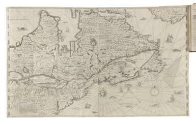
CHAMPLAIN, Samuel de (c.1570-1635). Carte de la Nouvelle France... imprimer en 1632 . Paris: 1632. Engraved map on two sheets joined, overall 530 x 860mm. The map showing the north eastern seaboard of North America from Chesapeake to Greenland and west to Hudson's Bay and the Great Lakes, the continent decorated with mountain symbols and various geographical and historial descriptions, arms of France, the seas decorated with ships and sea monsters, scale bar, sandbanks and obstructions noted, graticule border. (The map trimmed to plate mark, old repaired tear at lower centre fold, the left hand sheet more heavily inked, the right hand sheet showing more signs of plate wear.) "One of the outstanding maps of Canada, summarizing the whole of Canada's geography as it was known in the early 17th century", (Kershaw, Early Printed Maps of Canada , p.79). This example is the second state of this important map, the right hand sheet being re-engraved with a variant outline of the Newfoundland Grand Bank, and changes to Cape Breton island. The map was published in Champlain's Les Voyages de la Nouvelle France in Paris in 1632, and was specifically drawn up for that work by Champlain as a summary of his voyages and explorations in Canada from 1604 to 1618, extending his earlier map of 1613 into the Great Lakes and north to Hudson's Bay. Champlain's achievements in Canada as an explorer, geographer and founder of Quebec, were unprecedented and this magnificent map justly celebrates his work.
CHAMPLAIN, Samuel de (c.1570-1635). Carte de la Nouvelle France... imprimer en 1632 . Paris: 1632. Engraved map on two sheets joined, overall 530 x 860mm. The map showing the north eastern seaboard of North America from Chesapeake to Greenland and west to Hudson's Bay and the Great Lakes, the continent decorated with mountain symbols and various geographical and historial descriptions, arms of France, the seas decorated with ships and sea monsters, scale bar, sandbanks and obstructions noted, graticule border. (The map trimmed to plate mark, old repaired tear at lower centre fold, the left hand sheet more heavily inked, the right hand sheet showing more signs of plate wear.) "One of the outstanding maps of Canada, summarizing the whole of Canada's geography as it was known in the early 17th century", (Kershaw, Early Printed Maps of Canada , p.79). This example is the second state of this important map, the right hand sheet being re-engraved with a variant outline of the Newfoundland Grand Bank, and changes to Cape Breton island. The map was published in Champlain's Les Voyages de la Nouvelle France in Paris in 1632, and was specifically drawn up for that work by Champlain as a summary of his voyages and explorations in Canada from 1604 to 1618, extending his earlier map of 1613 into the Great Lakes and north to Hudson's Bay. Champlain's achievements in Canada as an explorer, geographer and founder of Quebec, were unprecedented and this magnificent map justly celebrates his work.
.jpg)
.jpg)

.jpg)


.jpg)


Testen Sie LotSearch und seine Premium-Features 7 Tage - ohne Kosten!
Lassen Sie sich automatisch über neue Objekte in kommenden Auktionen benachrichtigen.
Suchauftrag anlegen